Did You Know?
Malta’s Map Looks Exactly Like a Fish – and Nobody Talks About It
Millions of people visit Malta every year. Thousands more read about it, study it, or follow it online. And almost none of them have noticed what has been hiding on the map this whole time.
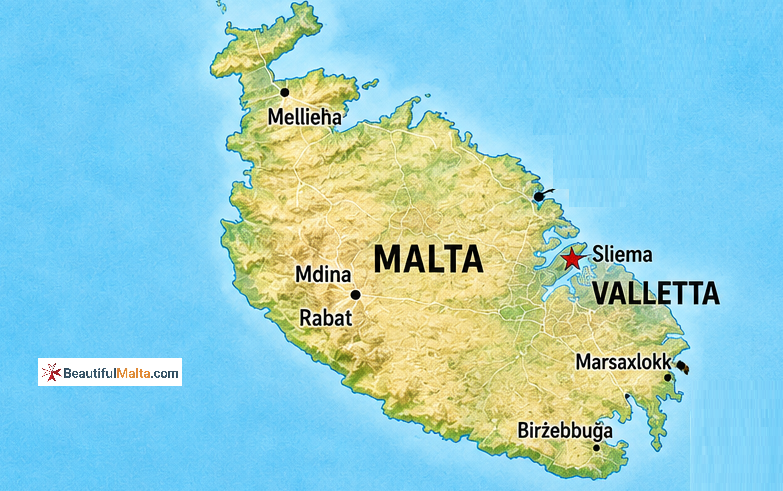
Go ahead. Open Google Maps right now. Search for Malta. Zoom out just enough to see the whole main island clearly – not too close, not too far. Just enough to see the full outline.
Now look at it. 
Look at the wide, rounded northern end – broader, fuller, like the body of something. Then follow the coastline south as it tapers gradually, narrowing toward the bottom. Notice the way the coastline on the sides curves and dips in places, almost like fins pressing against the water. And at the very southern tip, the land comes to a soft, slightly uneven point.
It is a fish.
Not vaguely. Not if-you-squint. If you look at the outline of Malta on a map with fresh eyes, it is unmistakably, almost comically, fish-shaped. A fat little Mediterranean fish, swimming southwest, surrounded by the very sea that makes it famous.
Once you see it, you cannot unsee it. And then comes the slightly unsettling question – how has nobody made more of this?
Malta is one of the most written-about small countries in Europe. Its history stretches back 7,000 years. Phoenicians, Romans, Arabs, Knights, Napoleon, the British Empire – everyone has had something to say about this island. Travel writers have described every bay, every fortress, every narrow street in Valletta. And yet the fish shape just sits there on the map, quietly, waiting for someone to notice.
Try it with someone who has never been to Malta. Pull up a map, point at the island, and ask them what shape it looks like. Most people get it within about ten seconds. Then watch their face when you tell them this is a country with 7,000 years of recorded history and a civilization that built the world’s oldest free-standing temples – and its outline looks like something you would order grilled at a seaside restaurant.
There is something almost poetic about it when you think about Malta’s story. This is an island whose entire identity was shaped by the sea. The Phoenicians came by sea and named it a haven. The Romans came by sea and brought their culture. The Arabs came by sea and gave Malta its language. The Knights came by sea and built its most famous city. The British came by sea and made it a naval base. Saint Paul arrived by sea – in a shipwreck, no less. Even today, Malta’s economy runs on the sea, whether through tourism, its port, or the maritime industries that have been here for centuries.
An island defined entirely by water, shaped like a creature that lives in it. You could argue the geography was always honest about what this place was going to be.
The fish shape becomes even more interesting when you zoom out a little further and look at the whole Maltese archipelago – the main island of Malta, the smaller sister island of Gozo to the northwest, and tiny Comino sitting between them.
Gozo has its own distinct outline, rounder and squatter. Comino is barely a speck. But Malta itself – the main island – is where the fish lives. It sits there in the central Mediterranean, about 90 kilometres south of Sicily and roughly 300 kilometres from the North African coast, this little fish-shaped piece of limestone that somehow ended up being one of the most strategically important and historically rich places in the entire Mediterranean basin.
The main island is only about 27 kilometres long and 14.5 kilometres wide at its broadest point. It covers roughly 246 square kilometres. To put that in perspective, it is smaller than the Isle of Wight. And yet within that fish-shaped outline, you will find three UNESCO World Heritage Sites, temples older than the pyramids, one of the best-preserved medieval walled cities in Europe, baroque architecture commissioned by an order of warrior knights, and the scars of one of the most intense bombing campaigns of World War II. All of it packed into a shape that looks like it should be swimming somewhere.
The limestone itself is worth a mention here. Malta is made almost entirely of globigerina limestone – a soft, warm-coloured rock that gives the entire island its distinctive golden-honey appearance. This is the same material the ancient temple builders used to construct Hagar Qim and Mnajdra. The same material the Knights of St. John used to build Valletta. The same rock that the island itself is carved from, slowly, by wind and sea over millions of years. The fish was always there in the stone. It just took the water to reveal the outline.
There is one more thing that makes the fish shape oddly satisfying from a historical perspective. The name Malta itself may – emphasis on may, because nobody is completely certain – derive from the ancient Greek word “meli,” meaning honey. The island was famous for its endemic bees and the distinctively dark, intensely flavoured honey they produced. Ancient writers mentioned it. The Romans prized it. Some scholars believe the Greeks literally named this place after what it tasted like.
So you have a fish-shaped island that might be named after honey, surrounded by the sea that shaped every chapter of its existence, covered in golden limestone that glows at sunset like something warm and edible.
Malta is, in every possible sense, a very sensory place.
The next time someone asks you about Malta – or the next time you find yourself trying to explain what makes this small island worth caring about – try this. Just open a map. Point at the shape. Let them find the fish on their own.
It tends to be the beginning of a much longer conversation about a place that has been hiding in plain sight, in the middle of the Mediterranean, for a very long time.
Some secrets are just waiting for someone to look at the right angle.