Living in Malta means accepting that, for four months of the year, your own coastline belongs to somebody else. Għadira turns into a mosaic of towels. Golden Bay becomes a competitive sport. And every hour another ferry pushes off for the Blue Lagoon carrying more people than the Blue Lagoon has room for.
So when we want an actual beach day, the kind where you hear water instead of a beach club’s playlist, we don’t go to any of those. We drive up past Selmun.
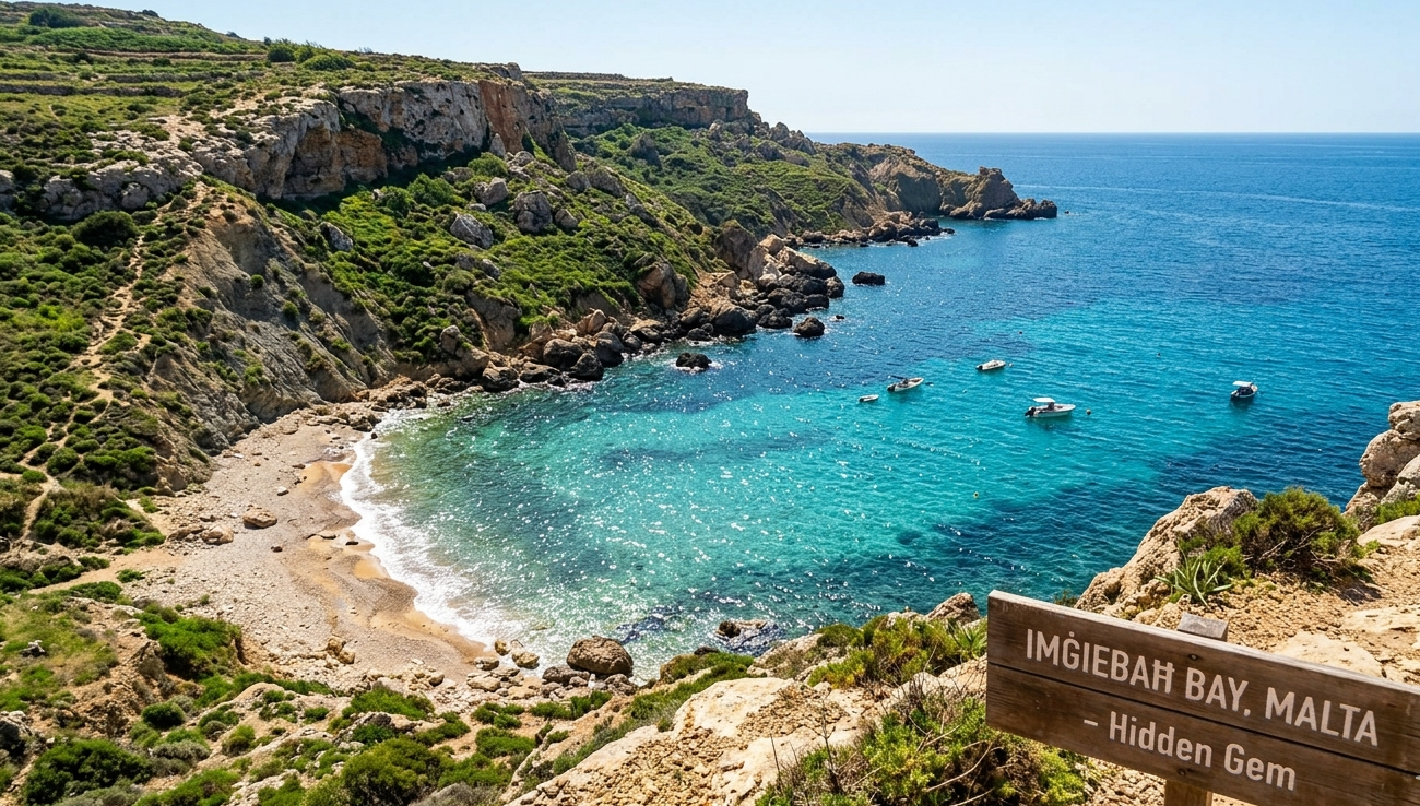
Imġiebaħ Bay, which half the island still just calls Selmun Bay, is a small cove on the north-eastern shoulder of Malta. It is raw, undeveloped and mildly inconvenient to reach, and those three facts are related. No sunbeds. No kiosk. No bins. No lifeguard. What you get instead is clean water, a short strip of dark gold sand, and quiet.
Here’s how we actually do a day down there: the drive, the descent, the packing list, and the mistakes worth skipping.
The name tells you something most visitors never learn
Imġiebaħ isn’t a pretty-sounding placeholder. In Maltese, miġbħa means an apiary (a place where bees are kept) and mġiebaħ is simply its plural. This is the Valley of the Beehives.
That name is doing real historical work. Cut into the rock in the valley behind the beach are ancient apiaries, chambers hollowed out for keeping bees that are generally attributed to the Punic and Roman periods. Malta produced honey the wider Mediterranean actually wanted. The Greeks knew the island as Melite, a name long associated with meli, their word for honey, although scholars still argue over whether that link is real or just a tidy coincidence. The same fingerprint shows up in place names across the island. Wied il-Għasel, the Valley of Honey, is the other obvious one.
So when you’re sitting on that sand, you’re sitting at the mouth of a working landscape that’s been quietly productive for something like two thousand years. It’s a better story than “hidden gem,” and almost nobody who visits knows it.
Why it stayed wild when everything else didn’t
Most of Malta’s sandy beaches surrendered to commerce a long time ago. Imġiebaħ survived largely because it makes you work for it. The access road filters out anyone who wants a cold drink handed to them on a lounger, which turns out to be an extremely effective form of crowd control.
It helps that the bay sits inside an EU Natura 2000 Special Area of Conservation, so the pressure to build here has never had anywhere to go.
The result is a genuinely dramatic bit of coast. The slopes behind the beach are blue clay, which is why they hold water, why they stay green with garrigue long after the rest of the island has gone brown, and why the sand carries that darker, tawny colour rather than the pale gold of Għadira. Above the clay sits harder limestone, cracked into boulders at the water’s edge. The sea is exceptionally clear, mostly because there’s no boat traffic and no runoff worth mentioning.
Watching the whole thing from the cliff to the north-east are the ruins of Għajn Ħadid Tower, built in 1658 as the very first of the De Redin watchtowers and reduced to a broken stump when the 1856 earthquake brought it down.
Getting there: the drive is half the adventure
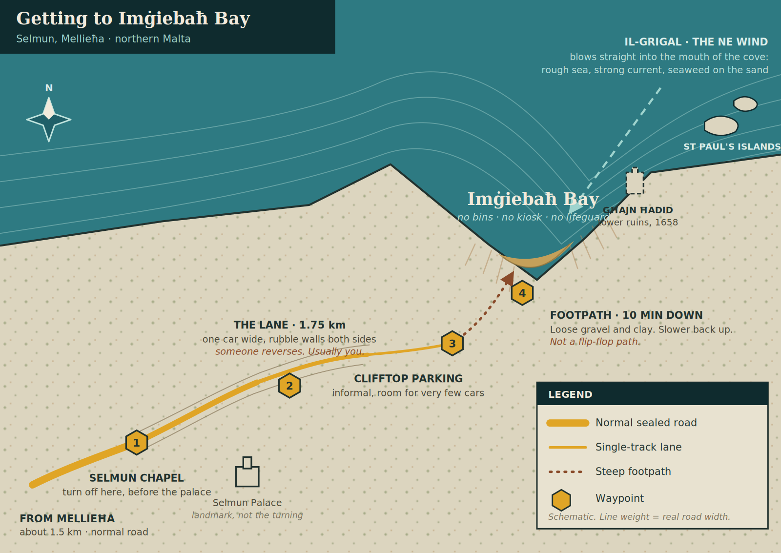
Imġiebaħ Bay is roughly 1.5 km from the centre of Mellieħa and about 14 km from Valletta, which sounds trivial until you meet the lane.
Head for Selmun from Mellieħa. The turning you want is by Selmun chapel, and this is the part people get wrong: you turn off before you reach Selmun Palace, not after it. The palace is your landmark, not your destination. (It’s an eighteenth-century villa built by the Monte della Redenzione degli Schiavi, the foundation that raised money to ransom Maltese captives from Barbary corsairs, and it’s worth ten minutes on the way out if you like that sort of thing.)
From there you’re on a country lane for about 1.75 km, and I want to be honest about it: it is barely wide enough for one car, walled on both sides with traditional rubble stone. There is no shoulder to drift into. Every local knows the specific dread of a blind corner on this road, because if you meet somebody coming the other way, one of you is reversing until you find a gap in the wall to tuck into. Usually you.
Drive slowly. Watch for farmers, cats, and potholes that could swallow a wheel.
The lane bends right, meets a crossroads, and you go left towards the coast. A couple of hundred metres later the ground opens out onto the clifftop and that’s your car park: informal, unmarked and small. On a July Sunday afternoon there will be nothing.
If you’d rather not drive it
Fair. Three alternatives, all of which locals use:
- On foot. You can walk in from the trail near the boathouses at Mellieħa, or simply park up at Selmun and walk the lane. It’s genuinely pleasant, all rubble walls and fields and birdsong, and it removes the reversing problem entirely. Allow 30 to 40 minutes each way.
- By kayak or paddleboard. Rent at Għadira and paddle round; it’s roughly half an hour of easy water on a calm day, and arriving by sea is by far the nicest way to see the cove open up in front of you.
- By bus, sort of. Public transport gets you to the Mellieħa and Selmun corridor and no further. From the nearest stop you’re looking at a solid walk. Doable, but check current routes before you commit, and remember the walk back is uphill at the end of a beach day.
The descent
From the car park, it’s about ten minutes down a steep path of dirt, loose gravel and clay. Nobody maintains it. Do not attempt it in flip-flops. I’ve watched people try, and it goes badly in a slow, undignified way. Trainers or proper walking sandals.
Two things worth knowing: after rain the clay turns genuinely slippery, and the climb back up in late-afternoon August heat takes noticeably longer than the walk down. Budget accordingly.
What a day down there actually looks like
With no facilities to structure your time, the day organises itself around the water.
Swimming
The middle of the bay has a sandy bottom that shelves gently, so walking in is easy and it stays shallow long enough for kids to be comfortable. Because the cove is tucked in, the surface often stays glassy well into the morning. Float on your back and you’re looking up at clay cliffs on three sides with nothing in your ears but wind.
Snorkelling the edges
The sand is the middle; the sides are limestone boulders, and that’s where the life is. Bring a mask. You’ll see saddled bream, damselfish hanging over the rocks in clouds, wrasse working the crevices, the occasional Mediterranean parrotfish, and, if you’re patient enough to spot the tell-tale pile of shells outside a hole, octopus. Visibility on a still day is excellent.
Do wear something on your feet. Sea urchins live on those rocks and they win every encounter.
Walking up to the tower
If you’ve had enough swimming, take the paths up the slopes. The views run out over the water towards St Paul’s Islands, and in spring the hills come up thick with wild thyme and coastal chamomile, the same flora that made this a beekeeping valley in the first place. If you’re up for a proper walk, carry on to the Għajn Ħadid Tower ruins, or south towards the remains of Fort Campbell, a 1930s British coastal defence work with big panoramic views.
Stay back from the crumbly edges. Blue clay slumps, especially after winter rain, and it doesn’t warn you.
What we pack
Imġiebaħ punishes the unprepared, because the correction for forgetting something is a twenty-minute round trip up a cliff.
- Twice the water you think you need. The hike back up is the hardest thing you’ll do all day. Leave a cold bottle in the car for when you reach it.
- Real shade. There is zero natural shade on that sand. A sturdy beach umbrella with a screw anchor, plus hat, sunscreen and a long-sleeve UV top.
- Two kinds of footwear. Trainers for the path, water shoes for the rocks and the pebbly patches near the waterline.
- Food in sealed containers. Leave a wrapper open and the ants find it in about four minutes. This is not an exaggeration.
- A rubbish bag. Non-negotiable, and I’ll come back to this.
- A small first-aid kit. Plasters, antiseptic, tweezers. You’re a long way from a pharmacy.
- Cash. Not for the beach, since there’s nothing to buy, but for whatever you stop at on the way home.
Timing it properly
Timing is most of the battle here.
Time of day. In summer, be parked by 8:30 am. You’ll get a space, you’ll get your pick of the sand, and you’ll get the calm water. The other good window is late afternoon into evening, once the day crowd has hauled itself back up the hill.
Time of year. The shoulder seasons are the real answer: May, June, September and October. Sea’s warm, heat’s manageable, and midweek in October you can quite reasonably have the whole cove to yourself.
Wind: check this before anything else. Every wind in Malta has its own name, and the one that ruins this particular beach is the Grigal: our north-easterly. The word comes from the Italian grecale, the “Greek wind,” because it arrives from the direction of Greece. Its neighbours on the Maltese compass are the Tramuntana from the north, the Lvant from the east and the Xlokk from the south-east.
Imġiebaħ faces north-east, so the Grigal blows straight into the mouth of the cove. When it does, the water turns choppy, the current strengthens, and seaweed piles up along the sand. It makes for a beach day nobody enjoys. Come on a day with southerly or westerly wind and it’s a completely different place. Any local forecast lists wind direction; make it the first thing you check, not the last.
Safety, honestly
No lifeguard patrols this bay, and there’s no safety equipment on site. That’s the trade you’re making.
- No lifeguard, no flags. Judge the sea yourself, and if it looks wrong, it is.
- Weever fish. They bury themselves in shallow sand and have venomous spines. A shuffle-step in the shallows rather than a stomp avoids the whole issue.
- Jellyfish. Mauve stingers turn up in Maltese water periodically, especially with onshore wind. Scan the surface before you go in.
- Sea urchins on every rock edge.
- Phone signal is patchy in the cove. Malta’s emergency number is 112, but be aware that getting help down to this beach takes time, which is the real argument for not swimming alone here.
- Cliff edges above the bay are undercut and clay-based. Keep children well back.
Bringing the dog
Imġiebaħ is one of the few decent stretches of sand in the north where dogs are genuinely welcome, and on any given morning you’ll find someone throwing a ball into the surf. It’s one of the reasons locals defend the place.
Come prepared, though: bring water and a bowl for the dog, keep an eye on hot ground in midsummer, and be realistic about whether your dog can handle that path in both directions. And pick up after them: carry the bags out with you, because there is nowhere to put them.
The one rule that keeps this place alive
There are no bins on that sand. Nobody comes to clean it. Every single thing you carry down, you carry back up.
We take leave-no-trace seriously here and we’re not shy about saying so. That means cigarette butts, bottle caps, fruit peel, the little corner you tear off a packet. All of it. Don’t build cairns, don’t pull up plants, don’t carve anything, and don’t light fires on the clay.
Imġiebaħ has stayed beautiful for one reason: enough people have chosen to leave it exactly as they found it. That’s the entire deal, and it’s not a difficult one.
Combine it with
- Selmun Palace. Five minutes back up the road, photogenic, faintly eerie with the abandoned hotel standing behind it.
- Mistra Bay. The next inlet along. Rockier, and a good fallback if Imġiebaħ is windblown.
- Mellieħa village. Where you go afterwards for food, because there is none anywhere near the bay.
- Fort Campbell. Ruined, atmospheric, excellent views, and almost no fences to speak of.
Frequently asked questions
Where is Imġiebaħ Bay?
Imġiebaħ Bay is on the north-eastern coast of Malta, in the Selmun area within the limits of Mellieħa. It’s roughly 1.5 km from the centre of Mellieħa and about 14 km from Valletta. It’s also known as Selmun Bay, and you’ll see it spelled Mġiebaħ or Mgiebah.
How do you get to Imġiebaħ Bay?
Drive towards Selmun from Mellieħa and take the turning by Selmun chapel, before you reach Selmun Palace. Follow the single-track lane for about 1.75 km, bear right at the bend, then turn left at the crossroads towards the coast to reach the clifftop parking area. From there it’s a ten-minute walk down a steep gravel path to the sand.
Is Imġiebaħ Bay sandy or rocky?
Both. The centre of the bay is sand with a gently shelving sandy bottom, which makes wading in easy. The edges are limestone boulders, and there are pebbly patches near the waterline. Water shoes are a good idea.
Can you drive all the way to Imġiebaħ Bay?
You can drive to the clifftop car park, but not to the beach itself. The final approach is a narrow single-track lane with rubble walls on both sides and very few passing places, and the last stretch to the sand is a footpath only.
Is there parking at Imġiebaħ Bay?
There’s an informal, unpaved parking area at the top of the cliff with room for only a handful of cars. It fills early on summer weekends. Arriving before 8:30 am in July and August is the reliable way to get a space.
Can you get to Imġiebaħ Bay by bus?
Not directly. Public transport reaches the Mellieħa and Selmun area, but from the nearest stop you face a significant walk to the bay, and the return leg is uphill. Check current Malta Public Transport routes before relying on it.
Are dogs allowed at Imġiebaħ Bay?
Yes. Imġiebaħ is widely used as a dog-friendly beach and is popular with local dog owners, unlike several of Malta’s main sandy beaches which restrict dogs during the summer season. Bring water for your dog and carry out any waste.
Are there toilets, cafés or sunbeds at Imġiebaħ Bay?
No. There are no toilets, no kiosks, no sunbed or umbrella rental, and no bins. Bring everything you need, including shade, and take all your rubbish home with you.
Is there a lifeguard at Imġiebaħ Bay?
No. There is no lifeguard service and no safety equipment on site. Mobile signal in the cove can be unreliable, and access for emergency services is slow, so swimming alone is not advisable.
Is Imġiebaħ Bay good for snorkelling?
It’s one of the better spots in northern Malta. The rocky margins on either side of the cove hold bream, wrasse, damselfish and octopus, and visibility is usually excellent because there’s very little boat traffic. Bring your own gear, since nothing is available on site.
When is the best time to visit Imġiebaħ Bay?
May, June, September and October offer warm water without the summer crowds or heat. Whatever the month, go early in the morning or late in the afternoon, and check that the wind isn’t blowing from the north-east, because the Grigal turns the bay rough and fills it with seaweed.
Is Imġiebaħ Bay suitable for families with young children?
The water is, since it’s shallow and sheltered with a sandy bottom. The access is the problem: a steep ten-minute path in each direction, no shade, no toilets and no lifeguard. It works well for confident older children and is hard work with toddlers or a pushchair.
What does the name Imġiebaħ mean?
It comes from the Maltese word miġbħa, meaning apiary or beehive; mġiebaħ is the plural. The valley behind the bay contains rock-cut apiaries attributed to the Punic and Roman periods, a reminder that Malta was known for its honey in antiquity.
What is the Grigal wind, and why does it matter here?
The Grigal is the Maltese name for the north-easterly wind, borrowed from the Italian grecale, meaning the “Greek wind.” It matters at Imġiebaħ because the cove opens to the north-east, so a Grigal blows directly into it, bringing choppy water, stronger currents and seaweed washed up on the sand. Check the wind direction before you set off and go on a southerly or westerly day instead.
Is Imġiebaħ Bay worth visiting?
If you want facilities, no. If you want one of the last undeveloped sandy coves in Malta, clear water, room to breathe and a beach where you can bring the dog, it’s worth every minute of the drive. Just go prepared, and go on a day the Grigal isn’t blowing.
Imġiebaħ takes effort. That effort is exactly what you’re buying. It’s the reason there’s still space on the sand in August, and the reason the water is as clear as it is.
Next time the resort beaches start to feel like a queue, pack properly, wear real shoes, and take the turn at Selmun chapel. There’s a quiet gold slice of Malta at the bottom of that path, and it’s been there a very long time.