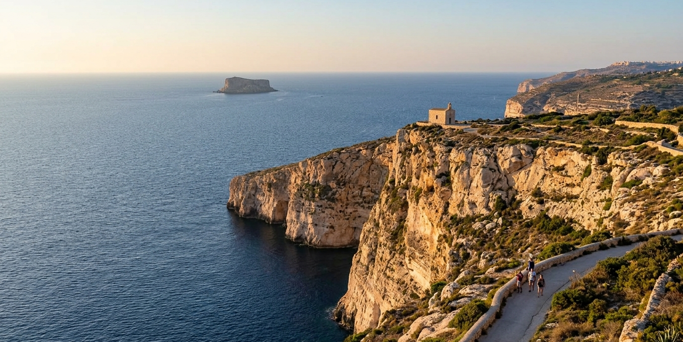
Most guides to Dingli Cliffs tell you the same three things: it is 253 metres high, it is the best sunset spot in Malta, and you can see Filfla from the top. Two of those are true. The third is true in a way that will still leave you looking in the wrong direction if nobody explains it properly.
This guide fixes that. You will get the actual sunset time for the month you are visiting, the bus that drops you at the cliff edge rather than in the village, the reason the cliff is not the sheer wall people expect, and the things worth stopping for within a kilometre of the viewpoint that almost nobody mentions.
Dingli Cliffs is the one place on this island where you can stand still, see nothing man-made in front of you, and hear only wind. It deserves a guide that gets the details right.
What 253 metres actually means
Ta’ Dmejrek, the high point on the Dingli Cliffs, sits 253 metres above sea level. That makes it the highest ground in the whole Maltese archipelago, and the figure is correct.
What is not correct is the sentence you will read almost everywhere else: that the cliff face “drops 253 metres straight into the sea.”
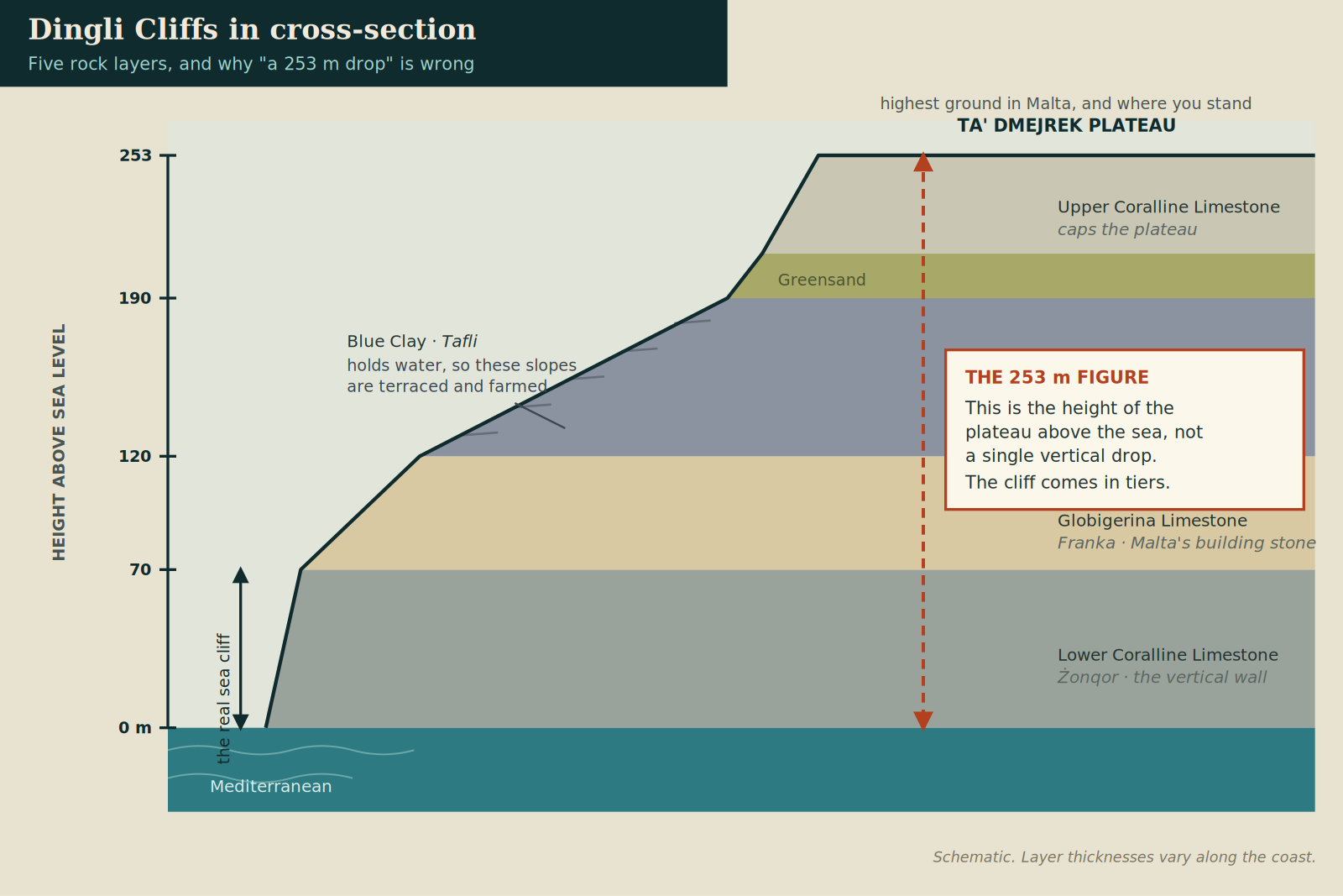
It does not. 253 metres is the height of the plateau you are standing on, measured from sea level. The drop in front of you is not one vertical wall. It comes in steps.
Dingli Cliffs in cross-section. The 253 metre figure is the height of the plateau above sea level, not the height of a single vertical drop.
Dingli is one of the few places where you can see the entire rock sequence of the Maltese Islands stacked in one view. From the bottom up:
Lower Coralline Limestone (Żonqor), the hard grey rock at the base. This is the genuine vertical sea cliff, and it is the part that plunges straight into deep water.
Globigerina Limestone (Franka), the soft golden stone that most of Malta is built from.
Blue Clay (Tafli), a blue-grey marl that holds water instead of letting it drain away. This is why the middle slopes are green, and why farmers terraced them centuries ago. Those little fields you can see below the road are growing on clay, not rock.
A thin band of Greensand.
Upper Coralline Limestone on top, forming the flat plateau under your feet.
So the honest description is a tiered cliff: a vertical wall from the sea, then cultivated clay slopes, then another wall up to the plateau. It is more interesting than a single drop, and it explains something you would otherwise find strange, which is how anyone managed to farm halfway down a cliff.
The reason the west coast has cliffs at all is tectonic. The Maltese Islands are tilted towards the north-east. That tilt lifted the western and south-western edge into these escarpments and drowned the eastern shoreline into the low, indented harbours around Valletta. Same island, two completely different coasts, one cause.
Sunset at Dingli Cliffs, with the actual times
The reputation is deserved. The cliffs face west and south-west across open water, there is no development in the way, and the light hits the pale limestone at a low angle for the last hour of the day.
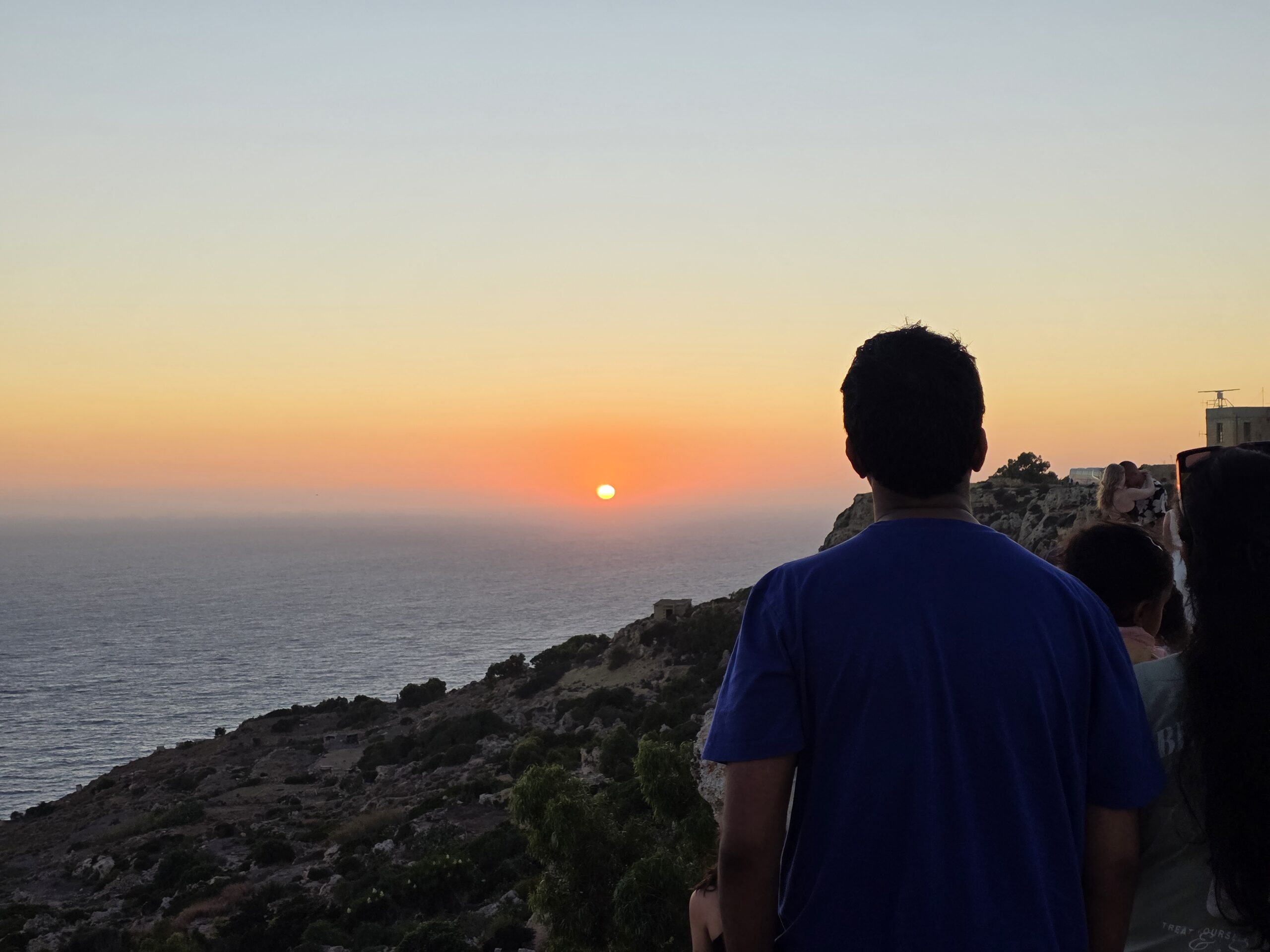
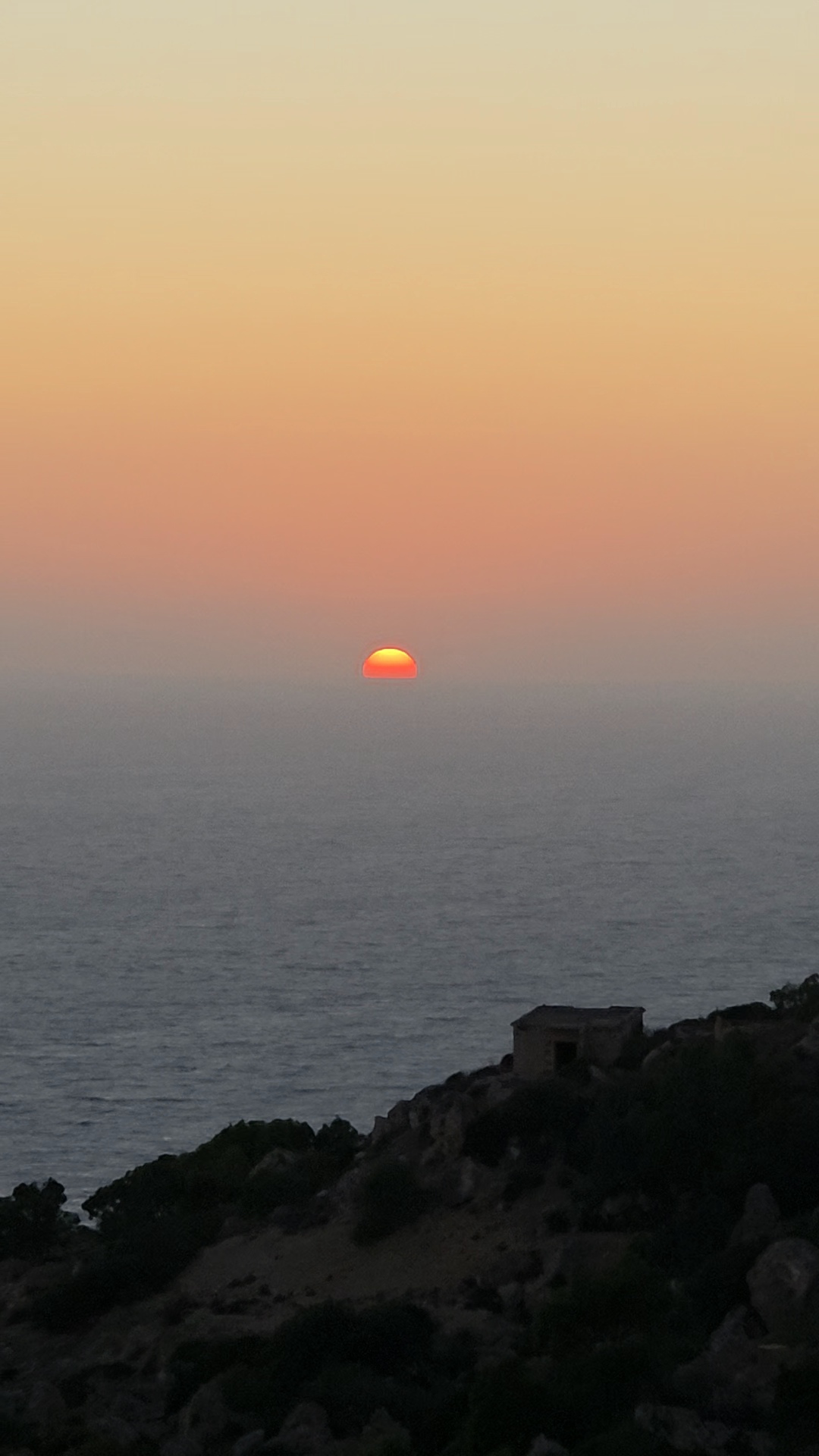
Sunset from the clifftop, photographed at 20:06 on 31 July. Sunset that evening was 20:07.
The mistake visitors make is arriving at the wrong time, usually because they looked up “sunset in Malta” and got a figure for a different month. Sunset here moves by more than three and a half hours across the year.
Month
Sunset
Golden hour starts
Fully dark
January
17:11
16:26
17:40
February
17:43
16:58
18:10
March
18:09
17:24
18:35
April
19:35
18:50
20:02
May
20:00
19:15
20:29
June
20:20
19:35
20:50
July
20:18
19:33
20:48
August
19:52
19:07
20:19
September
19:09
18:24
19:35
October
18:26
17:41
18:52
November
16:54
16:09
17:22
December
16:49
16:04
17:18
Times are for the 15th of each month at the chapel. The jump between March and April is the clocks going forward, not the sun.
The earliest sunset of the year is around 16:48 in the second week of December. The latest is 20:22 in late June. Arrive 45 minutes before the time in the table and you will catch the whole golden hour rather than the last four minutes of it.
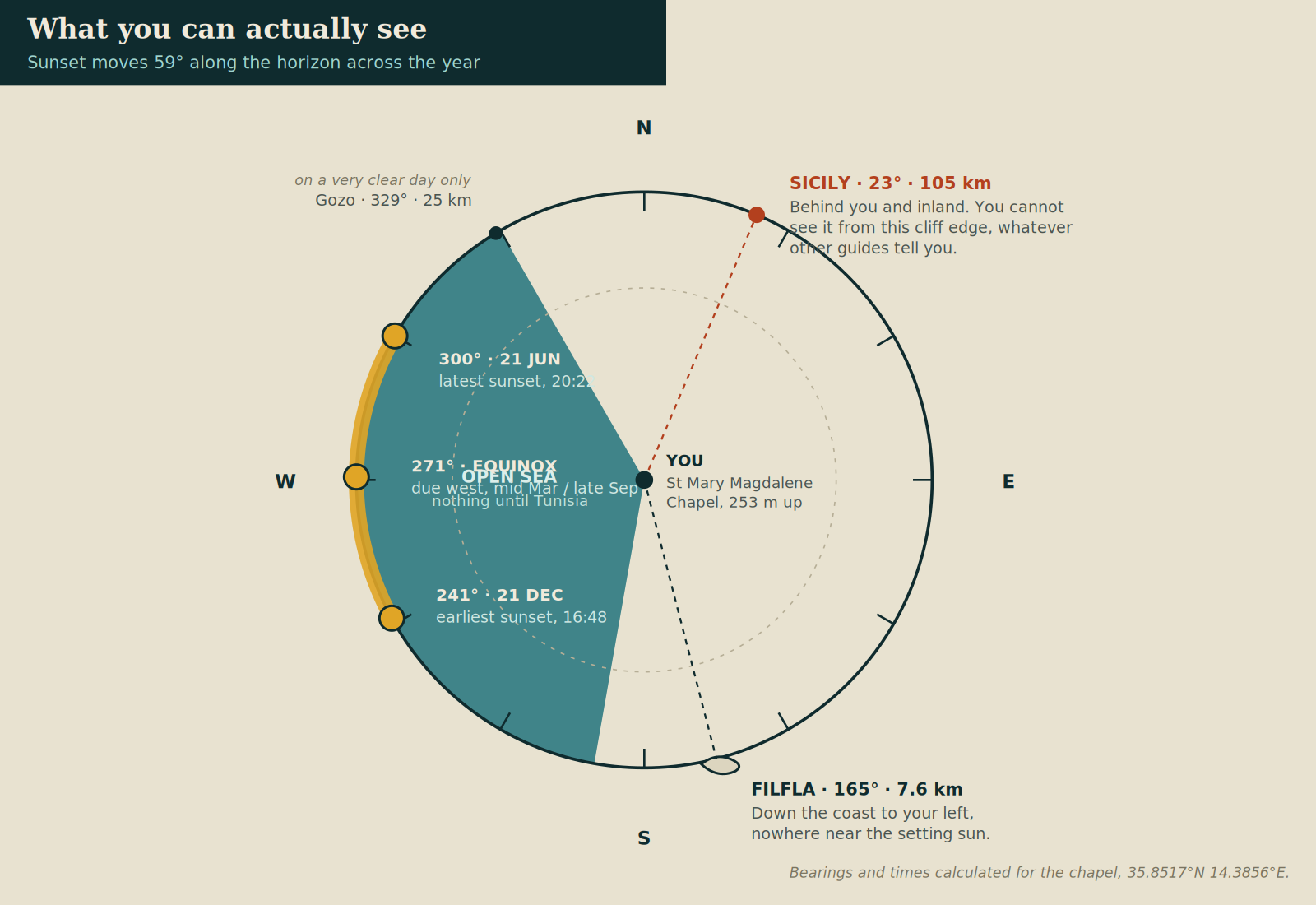
One detail worth knowing: the sun does not set in the same place each night. In late June it goes down at a bearing of 300 degrees, well to the north of west. At the December solstice it sets at 241 degrees, well to the south. That is a 59 degree swing along the horizon, which matters a great deal if you have a particular composition in mind.
What you are actually looking at
Where the sun sets across the year, where Filfla actually sits, and why Sicily is not visible from the cliff edge.
Filfla is not where you think it is
Filfla, the uninhabited islet, is the thing everyone wants to spot. But it is not straight out to sea in front of you. From the chapel it sits at a bearing of about 165 degrees, which is south-south-east: down the coastline to your left, not out towards the sunset.
It is also further away than most guides say. The commonly quoted “4.5 kilometres” is the distance from Malta’s nearest coast, over by Ħaġar Qim. From Dingli Cliffs it is roughly 7.6 kilometres.
Filfla itself is worth knowing about. It is a crumbling flat-topped limestone plateau of about 3.7 hectares, ringed by its own 60-metre cliffs, and it is strictly off limits. Landing is permitted only for scientific work. The reason is what lives there: an estimated 5,000 to 8,000 breeding pairs of European storm petrel, which is one of the largest colonies in the Mediterranean, plus roughly 200 pairs of Cory’s shearwater and 130 pairs of yellow-legged gull. Two species exist nowhere else on earth, the Filfla wall lizard and a door snail.
The name is a fossil of the island’s Arabic layer. Filfel means chilli pepper, which is roughly the shape it used to be, and old nautical charts label it with the Latin Piper.
For most of the twentieth century the British used Filfla for naval and aerial target practice. That is also why the surrounding waters are still treated with caution.
You cannot see Sicily from here
You will find travel articles claiming Sicily is visible from Dingli Cliffs on a clear day. It is not, and the geometry is simple. Sicily lies at a bearing of about 23 degrees from the chapel, roughly 105 kilometres away to the north-north-east. That is behind you and over the island, not out across the water.
Sicily genuinely is visible from Malta occasionally, but from the northern end: Marfa Ridge, the high ground above Mellieħa, the Red Tower. Not from here.
Gozo, at 25 kilometres and a bearing of 329 degrees, sits at the very edge of the seaward view to your right. On an exceptionally clear day you may pick out its outline. Most days you will not.
Two minutes after sunset, looking out from the cliff edge.
Stargazing and the August meteors
The clifftop is one of the darker accessible spots on a small, brightly lit island, and the whole southern and western sky is open water. In the second week of August the Perseid meteor shower peaks, and people do come up with blankets and sit out.
Be realistic about it. Malta has real light pollution and the glow from the towns behind you never fully disappears. But it is still among the better options on the island, and it costs nothing to try.
The chapel on the edge
Walk along Triq Panoramika and you come to a small stone building sitting on its own near the drop. This is the Chapel of St Mary Magdalene, known to Maltese speakers as il-kappella tal-irdum, the chapel of the cliffs.
The building you see dates from 1646, but a chapel has stood on this spot far longer. The earliest documentary reference is 1446. By 1575 the Inquisitor Dusina recorded it as barely standing, and it later collapsed altogether. It was rebuilt and reopened on 15 April 1646 by Bishop Miguel Juan Balaguer Camarasa, and the Latin inscription above the door still records the event.
Two details that most visitors walk straight past:
Beside the doorway is a plaque installed in 1777 reading non gode l’immunità ecclesiastica. Translated: this chapel does not grant church immunity. Many Maltese chapels could be used as sanctuary by someone fleeing the law. This one was formally marked as an exception, which tells you something about who was turning up at a remote clifftop chapel and why.
The building has also been struck by lightning more than once. A strike in 1936 damaged the façade, and another in December 2014 damaged the window and altar, after which it was restored and reopened.
It served the farmers working the terraced fields below, and it doubled as a navigation landmark for fishermen working this side of the island. It is usually locked, but the forecourt is open and it is the natural gathering point at sunset. Every 22 July, the feast of Mary Magdalene, mass is celebrated here and there is a bonfire afterwards.
Walking the cliffs, honestly
Dingli gets described as a hiking destination. It is worth being straight about what that means, because visitors regularly arrive expecting a marked coastal trail network and find something different.
Most of the walking is on or beside a road. Triq Panoramika runs along the clifftop and it is genuinely scenic, with the drop on one side and fields on the other. But it is tarmac, and cars use it.
That does not make it a bad walk. It makes it an easy, accessible one with a continuous view, which suits a lot of people. Just know what you are choosing.
If you want to get away from the road:
South towards Fawwara. The most rewarding stretch. Head south from the chapel and the landscape opens into terraced fields, rubble walls and old farm buildings, with the sea on your right the whole way. Allow about two hours for a there-and-back walk.
Inland to Buskett. Buskett is Malta’s only real woodland, planted by the Knights of St John as hunting grounds beside Verdala Palace. Walking from the clifftop down into it takes you from bare, wind-scoured garrigue into actual shade in about twenty minutes. In a Maltese summer that transition is not a small thing.
Underfoot, expect bare limestone, loose stone and low spiny scrub. It is uneven rather than difficult.
The plants are worth a glance. The clifftop garrigue holds Mediterranean thyme, and the inaccessible ledges below are one of the last strongholds of the Maltese rock-centaury, widnet il-baħar, which is Malta’s national plant and grows wild nowhere else in the world.
The thing next door that nobody tells you about
Roughly a kilometre inland, between the cliffs and Buskett, is Misraħ Għar il-Kbir, better known as Clapham Junction. It is the densest concentration of prehistoric cart ruts anywhere in Malta, and it is free, unfenced and usually empty.
Cart ruts are paired grooves cut into the bare limestone, running across the landscape, crossing each other, occasionally heading straight off a cliff edge. At this site they are up to 60 centimetres deep with a typical gauge of 110 to 140 centimetres. Nobody knows for certain who made them or why. Estimates range from the Temple Period, around 3800 to 2500 BC, through to medieval times, and it is entirely possible they were made and reused across different eras for different reasons.
The nickname came from the archaeologist David Trump, who thought the tangle of tracks looked like the railway junction in south London.
Right beside the ruts is Għar il-Kbir, a complex of natural caves enlarged by hand and lived in continuously until 1835, when the British authorities moved the last residents to Siġġiewi on health grounds. It had been documented since the fifteenth century, and in the seventeenth the scholar Athanasius Kircher visited and wrote about the community living there.
You can stand on cart ruts of unknown age, look down into a cave that was somebody’s home within the last two hundred years, and see the cliffs a kilometre away. For a free, unsupervised site, it is remarkable.
Combining it into a day
Distances below are measured from the chapel.
Clapham Junction and Għar il-Kbir, 1.1 km. Ten minutes by car, walkable.
Buskett Gardens, 1.2 km. Shade, picnic tables, and the only proper woodland in the country.
Għar Lapsi, 3.7 km. A natural rocky inlet at the foot of the cliffs with clear, sheltered water. This is where you swim, because you cannot swim at Dingli itself.
Ħaġar Qim and Mnajdra, 5.8 km, about 10 to 15 minutes by car. Megalithic temples older than Stonehenge and the pyramids at Giza, and a UNESCO World Heritage Site.
Dingli village, just inland. Small, quiet, and the place to eat. This part of Malta is fenkata country, so if you want rabbit stew done properly, this is where to have it.
Mdina, about 6 km. The walled old capital, and an easy pairing with the cliffs by car or on route 201.
Getting there
By bus, and please ignore what other guides say
This is where most guides get it wrong, including ones that otherwise know Malta well. The usual line is that the bus drops you in Dingli village and you walk fifteen minutes to the cliffs. That is true of one route and not the other.
Route 201 stops at the cliffs themselves. The stop is called Cliffs. Route 201 runs Rabat to Dingli to Dingli Cliffs to Siġġiewi to Ħaġar Qim to the Blue Grotto to Żurrieq to the Airport, which also makes it the single most useful bus in this part of Malta: it links the cliffs directly to the temples and the Blue Grotto without a change.
It is roughly hourly, and it is the last bus back that catches people out. Departures from the Cliffs stop finish around 21:19. In June and July, with sunset at about 20:20, that leaves you a workable but tight window.
Routes 52 and 56 go to Dingli village, not the cliffs, and from there it is a walk of about 15 to 20 minutes. Route 52 runs to and from Valletta roughly every 30 minutes and continues much later into the evening, which makes it the safer choice if you are staying for sunset.
Bus routes and timings in Malta do change. Check the Malta Public Transport site or app on the day, especially for the last departure.
By car
Driving is easiest. There is free roadside parking along Triq Panoramika and a small area near the chapel. It fills in the hour before sunset in summer, and coach tours use the same space during the day. Arrive early or park further along the road and walk.
On foot from Rabat or Mdina
About 5 to 6 kilometres, a little over an hour. Pleasant in spring and autumn, punishing in July.
Safety, because nobody else says it
There are no barriers along most of the clifftop. No railings, no fence, no lifeguard, no warden. The edge is exactly that, and in several places it is undercut, with rock overhanging nothing.
This is not a reason to stay away. It is a reason to behave sensibly:
Stay well back from the edge, and further back than feels necessary when it is windy. Wind at a cliff edge does not behave predictably.
Do not sit with your legs over the drop for a photograph. The rock at the lip is the most weathered rock on the cliff.
Keep children within reach at all times, and dogs on a lead.
The clay slopes become slippery and unstable after rain.
In summer there is no shade whatsoever on the clifftop.
Malta’s emergency number is 112. Signal is generally fine here, but a cliff rescue takes time.
What to bring
Water. More in summer than you think, since there is nothing to buy at the cliff edge.
Sun protection. Hat, sunglasses, high-SPF sunscreen. Zero shade.
A layer for the evening. The wind picks up as the sun goes down, and people who came for sunset in a t-shirt regret it from about October to May.
Proper shoes if you are leaving the tarmac. The limestone is uneven and sharp.
A torch if you are staying past sunset. There is no lighting on the clifftop, and it gets dark faster than you expect.
A bag for your rubbish. Bins are scarce and the wind takes anything loose straight over the edge.
Frequently asked questions
How high are the Dingli Cliffs?
The highest ground is Ta’ Dmejrek at 253 metres above sea level, which is the highest point in the Maltese Islands. That figure is the height of the clifftop plateau, not the height of a single vertical drop. The cliff is tiered, with a vertical sea cliff at the base, cultivated clay slopes in the middle, and a rock cap on top.
Are Dingli Cliffs the highest point in Malta?
Yes. Ta’ Dmejrek on the Dingli Cliffs is the highest point in Malta and in the Maltese archipelago, at 253 metres. There is no dramatic summit to climb, since the clifftop is a broad, almost flat plateau.
What time is sunset at Dingli Cliffs?
It ranges from about 16:48 in early December to about 20:22 in late June. In midsummer expect roughly 20:20, in midwinter roughly 16:50, and around 19:00 to 19:10 at the equinoxes. Arrive 45 minutes early for the golden hour.
Can you see Sicily from Dingli Cliffs?
No. Sicily lies about 105 kilometres to the north-north-east, which from Dingli is behind you and across the island rather than out to sea. Sicily is sometimes visible from northern Malta, such as Marfa Ridge above Mellieħa, on exceptionally clear days.
What island can you see from Dingli Cliffs?
Filfla, a small uninhabited islet about 7.6 kilometres away. Look south-south-east, along the coastline to your left, rather than straight out towards the sunset. Gozo is occasionally visible far to the right on very clear days.
Can you visit Dingli Cliffs at night?
Yes. The clifftop is open, unfenced public land with no gates or opening hours, and people go up for stargazing, particularly for the Perseid meteor shower in mid August. Bring a torch, stay well back from the edge, and remember there is no lighting at all.
How do you get to Dingli Cliffs by bus?
Take route 201, which stops at the cliffs themselves at a stop called Cliffs and runs between Rabat and the Airport via Ħaġar Qim and the Blue Grotto. Routes 52 and 56 go to Dingli village instead, leaving a walk of about 15 to 20 minutes. Check the last departure before you commit to staying for sunset.
Is there parking at Dingli Cliffs?
Yes, and it is free. There is roadside parking along Triq Panoramika and a small area near St Mary Magdalene Chapel. It fills up in the hour before sunset during summer and when coach tours are in.
Are Dingli Cliffs free to visit?
Completely. There is no entrance fee, no ticket, no gate and no opening hours. The chapel is usually locked, but its forecourt and the whole clifftop are freely accessible.
Are there toilets, cafés or shops at Dingli Cliffs?
Not at the viewpoint itself. There are a couple of places to eat along the clifftop road and more in Dingli village, but at the chapel and the main viewing area there is nothing. Bring water.
Can you swim at Dingli Cliffs?
No. There is no sea access from the cliffs and no path down to the water. The nearest swimming is Għar Lapsi, a natural rocky inlet about 3.7 kilometres away, which has clear sheltered water and is popular with Maltese families.
Is there a proper walking trail at Dingli Cliffs?
Not a waymarked coastal path in the way visitors often expect. Most walking follows Triq Panoramika, the tarmac clifftop road, which is scenic and easy but shared with cars. For something more rural, walk south towards Fawwara or head inland to Buskett Gardens.
How long do you need at Dingli Cliffs?
Half an hour for the viewpoint and the chapel. Two to three hours if you walk a stretch of the coast, and a full day if you add Clapham Junction, Buskett Gardens and Ħaġar Qim, all of which are within six kilometres.
Are dogs allowed at Dingli Cliffs?
Yes. It is open public land and dogs are commonly walked along the clifftop road. Keep them on a lead, since there are no barriers at the edge and the road carries traffic.
When is the best time of year to visit Dingli Cliffs?
Spring and autumn. March to May brings wildflowers and comfortable walking temperatures, and September to November gives you warm evenings without the summer heat. Summer works for sunset but offers no shade at all, and winter brings a cold, strong wind straight off the sea.
Dingli Cliffs does not need to be oversold. It is a plateau, a chapel, a road, a drop and a great deal of open water, and it happens to be the highest, quietest and best-lit place on a very crowded island.
Go for the last hour of daylight, stand further back from the edge than you want to, and look south-east for Filfla rather than straight out to sea.