Did you know?
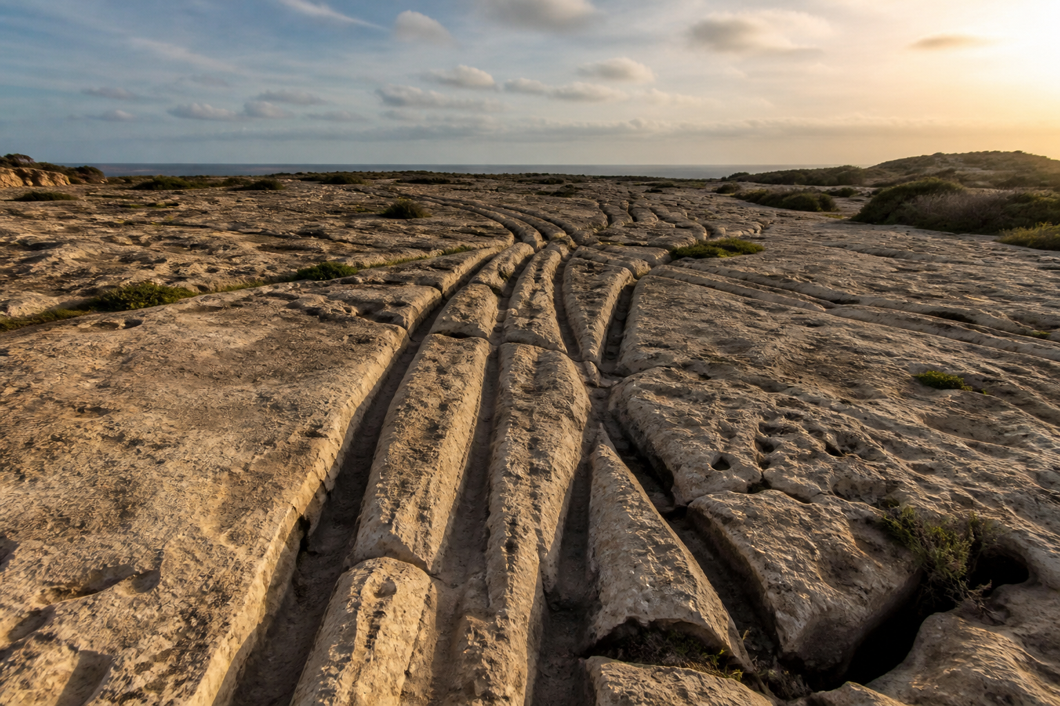
Somewhere on a windswept plateau near Dingli, there’s a patch of bare rock that looks like the world’s oldest railway yard. Pairs of deep grooves run across the stone in every direction. They cross each other, split apart, curve away and sometimes disappear right off the edge of a cliff.
The British gave the place a nickname: Clapham Junction, after one of London’s busiest railway stations. The name stuck, because it’s honestly the best description anyone has come up with. What nobody has managed to come up with, after more than a century of research, is a clear answer to the obvious question.
Who made these grooves, and how?
What exactly are the cart ruts?
The cart ruts are parallel channels cut into Malta’s limestone. They usually come in pairs, roughly a metre and a half apart, a bit like the tracks a cart leaves in mud, except these are in solid rock. Some are just a few centimetres deep. Others are so deep you could lose your foot in them, sinking well over half a metre into the stone.
They’re not just at Clapham Junction. You’ll find them all over Malta and Gozo, often in places where the bedrock is bare and close to the surface. There are hundreds of tracks in total, which makes the Maltese islands one of the most concentrated sites of this kind anywhere in the world.
The official name for the Clapham Junction site is Misraħ Għar il-Kbir, which means “the field of the big cave”. It’s the most famous spot because there are so many tracks in one place, crossing and merging like a tangle of old roads.
The strangest part: ruts that run into the sea
If deep grooves in rock weren’t puzzling enough, some of the cart ruts on Malta simply carry on walking straight into the water. Near Birżebbuġa, in the south of the island, pairs of ruts can be seen running down into the sea and continuing underwater. Others end abruptly at the edge of a cliff, as if whatever made them drove straight off it.
The most likely explanation is a little less dramatic than it first sounds. The ruts were made when the land and the coastline looked different. Over thousands of years, sea levels changed, the ground shifted and pieces of cliff collapsed into the sea. So the tracks didn’t lead into the water when they were made. The water came to them.
It still doesn’t stop people from coming up with wilder ideas, and you’ll find plenty of those online.
So who made them?
This is where it gets genuinely difficult. The cart ruts are cut into rock, so they’re very hard to date. There’s no wood, no bone, no charcoal left inside a groove that scientists can test.
Most archaeologists think they were made sometime between the Bronze Age, roughly 2000 BC, and the Punic and Roman periods, when Malta was busy and farmed. Some ruts may be much older than others. It’s quite possible they were used, reused and deepened over many centuries by different people.
What we can say is that they almost certainly weren’t made in one go, and they weren’t made by one group with one plan. They look more like the slow marks left by everyday life, repeated again and again until the rock gave way.
The main theories
1. Carts with wheels
The simplest idea is right there in the name. Carts with wooden wheels, pulled by animals, rolling the same routes over and over. Malta’s soft limestone can wear surprisingly quickly, especially when wet. Over time, the wheels would cut deeper and deeper until the cart was running in a channel.
The problem? Some ruts are so deep that a normal cart would have got stuck, and the gap between them isn’t always the same, which you’d expect it to be if every cart had the same axle.
2. Sledges or “slide cars”
Another theory says the grooves were made by a kind of sledge: two long wooden poles with the ends dragging along the ground, pulled by people or animals. This kind of vehicle was used in many places around the world before wheels became common. The dragging ends would wear V-shaped grooves into the rock, which matches the shape of many of the Maltese ruts.
3. Moving stone and soil
Some researchers think the ruts were tied to quarrying and farming. Malta has always been short of good soil, and people may have moved soil and stone around the island to build fields. Heavy loads, travelling the same routes again and again, could explain why the grooves are so deep in places.
4. Water channels
A less popular theory suggests some of the grooves were channels for collecting or moving rainwater. It’s an idea that makes sense on an island where water has always been precious, but it doesn’t explain why the grooves come in neat parallel pairs.
5. The theories that get shared online
Ancient giants, lost civilisations, a sunken continent. You’ll find them all if you search for long enough. They make for fun reading, but there’s no evidence for any of them. The real story, of ordinary people shaping their island over centuries with simple tools and a lot of patience, is impressive enough.
Want to see one up close without leaving the city? The National Museum of Archaeology in Valletta has a reproduction of the cart ruts on display.
The caves next door
Right beside Clapham Junction is Għar il-Kbir, the “big cave” that gives the site its Maltese name. People lived in and around this cave for a very long time. Visitors in past centuries wrote about a small community of families who made their homes in the caves here, until they were moved out in the 19th century. Standing at the cave entrance, with the ruts stretching away across the rock, you really get a sense of how many generations have walked this same ground.
How to visit Clapham Junction
- Where: on the plateau between Dingli and Siġġiewi, not far from Buskett Gardens. Search for “Clapham Junction cart ruts” or “Misraħ Għar il-Kbir” on Google Maps.
- Cost: free. It’s an open site with no ticket office.
- When: late afternoon is lovely, when the low sun makes the grooves stand out in sharp shadow. Avoid the middle of the day in summer, as there’s no shade.
- Getting there: it’s easiest by car. You can also walk from Buskett Gardens, which is a nice way to make a short countryside walk out of it.
- Be respectful: don’t drive, cycle or walk inside the ruts, and never scratch or chip the rock. These grooves have survived thousands of years. Let’s keep it that way.
Combine it with a sunset at Dingli Cliffs, just a few minutes away, and you have one of the most peaceful half days you can spend in Malta.
Why it matters
Most of Malta’s ancient sites come with signs, ticket desks and well-told stories. The cart ruts don’t. They’re just there, scratched into the island, asking a question nobody has fully answered.
And maybe that’s the best thing about them. In a world where you can look up almost anything in seconds, there’s still a field on a small Mediterranean island where you can stand, look down at the rock and wonder.
Love a good mystery? Malta has plenty. Read about the ancient temples that are older than the pyramids, or discover the hidden fish shape of Malta that’s been on the map all along.